
Deep Electrical Resistivity Tomography (DERT)
True resistivity and Chargeability (IP) 3D Imaging down to 1.5 Kilometers.
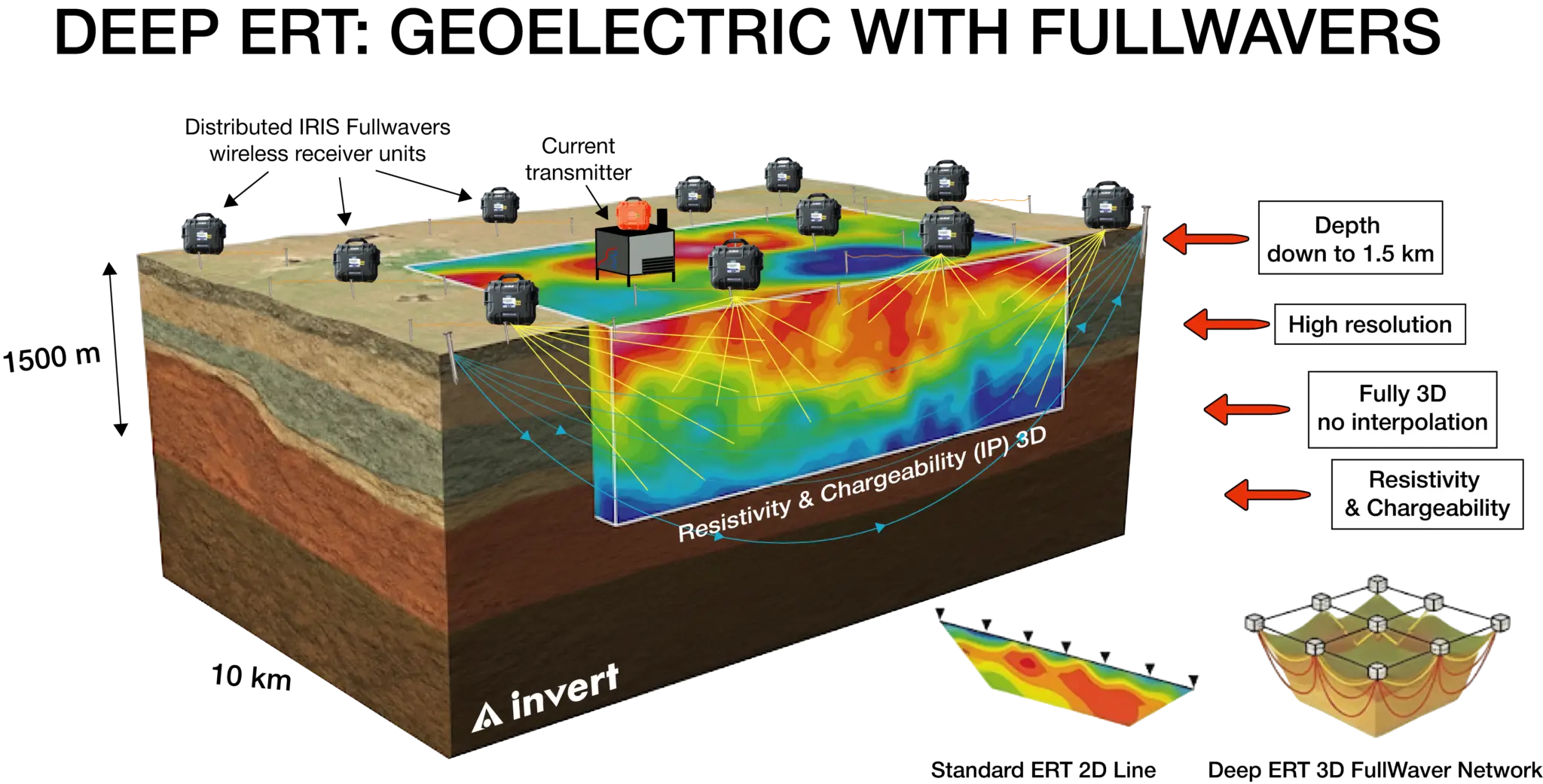
Unmatched Depth & 3D
We improve ERT current penetration depth by using networks of IRIS FullWaver receivers, that allow us to investigate in ideal conditions down to 1.5 km with a high degree of lateral resolution.
Deep ERT is fully 3D thanks to the flexibility of the FullWaver, eliminating the need for interpolation between standard 2D lines.
We invert for resistivity and chargeability (IP)
Conventional ERT is widely used in mineral exploration, but often runs up against limitations in the field or fails to investigate deeper structures.
Our advanced approach delivers 3D resistivity and IP models down to 1.5 kilometers, supported by a flexible acquisition network that adapts seamlessly to any topography or inhabited area. Deep Electrical Resistivity Tomography is an ideal tool for geothermal exploration. It allows us to directly image conductive regions enriched in fluids, such as aquifers, which can be harnessed for heat production.
If your project targets a specific fault system that channels hot fluids or can be engineered in this way, we can detect it by identifying lithological contrasts created by the fault itself or by pinpointing zones where the fault facilitates the circulation of fluids through the crust. We adapt our survey to all scales, from the development of geothermal power plants to the research of water or heat sources for private customers.
Deep Electrical Resistivity Tomography
Resistivity
Reveals how the subsurface conducts electrical current.
Conductive values point to clays, saline water, or mineralized zones, while Resistive values highlight bedrock, cavities, and dry formations.
ERT delivers high-resolution images used to map:
• Aquifers & groundwater pathways
• Cavities
• Faults, fractures, discontinuities
• Weathering profiles
• Lithological boundaries
• Ore deposits & alteration zones
Induced Polarization / Chargeability
Measures how subsurface materials store and release electrical charges.
High chargeability often indicates sulfides, disseminated mineralization, or saline/brine-filled zones.
When combined with ERT, IP provides a powerful dual dataset to confidently discriminate rock alteration, mineralization, and saline brines.